On our third morning in Iceland, we woke to a wonderful breakfast from Sigga. Breakfast in most of the guesthouses consists of cereal/granola with yogurt, skyr, milk, or sour milk, sliced cukes and tomatoes, lunch meat and cheese slices, various kinds of toast (usually with AMAZING homemade berry jam), hard boiled eggs. Generally, it was delicious and an excellent way to start the day.
We planned on hiking the Fimmvörðuháls Trail as far as we could (out and back). The trail is about 25 km (15 miles) and runs from behind the Skógafoss northward to Þórsmörk, which is the end point for the famous Laugavegur Trail running from Landmannalaugar to Þórsmörk. One could hike both trails in the same direction, but they are both best enjoyed heading towards Þórsmörk. The Fimmvörðuháls trail is broken up into three sections and generally hiked in a single day. The first section is about 8 km and runs along an ever-deepening river gorge. This section starts with Skógafoss and is said to have an additional 22 waterfalls along the way, each more beautiful than the last. The second portion of the hike takes you through the new lava fields created by the 2010 eruption of Eyjafjallajökull (and, yes, I can pronounce that). The last section takes you across the Morinsheiði plateau. We couldn't get to Landmannalaugar in May because of the snow and most of the Fimmvörðuháls Trail would be impassable, but we planned on trying to reach the end of the first section before turning around.
We didn't even get close.
It was about 40° and raining. We had layers and rain gear (for us and the camera). We had sandwiches. We thought we were prepared. And truly, L was okay but I ended up cold. So very cold! If you plan to do much in the cold rain, I would definitely look into waterproof gloves. I think I could have handled the situation much longer if my fingers weren't soaked and freezing. Also, I would recommend replacing your rain coat if it's 10 years old.
Anyways, before we started, I made us sandwiches for lunch in the back of the Vitara.

We decided since it was raining so hard in the beginning to keep the camera secure in the pack and take pictures on the way back. The very beginning of the trail is a staircase next to Skógafoss. Lots of steps and really, if you're not doing the hike, its not that cool. But, then you cross a fence and head north. The first part of the trail is pretty easy with a gorge on one side and pasture on the other. Its pretty flat with tons of gorgeous views of the waterfalls. Then, things change. There's a section where you get down into the gorge a bit and have to climb back out. I just about had a panic attack climbing out. There was a huge drop to my right and I had to climb, with freezing, numb fingers up a skree slope. I was pretty nervous about climbing up, but knowing I would have to do it again DOWN to get back was terrifying. But, I did it. Once we got back to the top of the gorge, the landscape had changed. It was rocky and almost moon-like with very little vegetation. Eventaully, the rocks gave way to grass again-- and snow. Lots of snow. We trekked through the snow for a while until we couldn't see a trail marker that wasn't in the snow. We really weren't prepared for hiking in the snow which is much harder on your legs than regular hiking. So, we decided to turn around.
We made it to about 3.5km.


Part of the reason I don't like hiking in the snow is because I have no idea what's underneath and whether or not it can support my weight. I'm sure we would have been fine, but we didn't want to take any chances on the third day of vacation.

We might not have made it as far as we wanted, but the waterfalls we did see were truly spectacular!


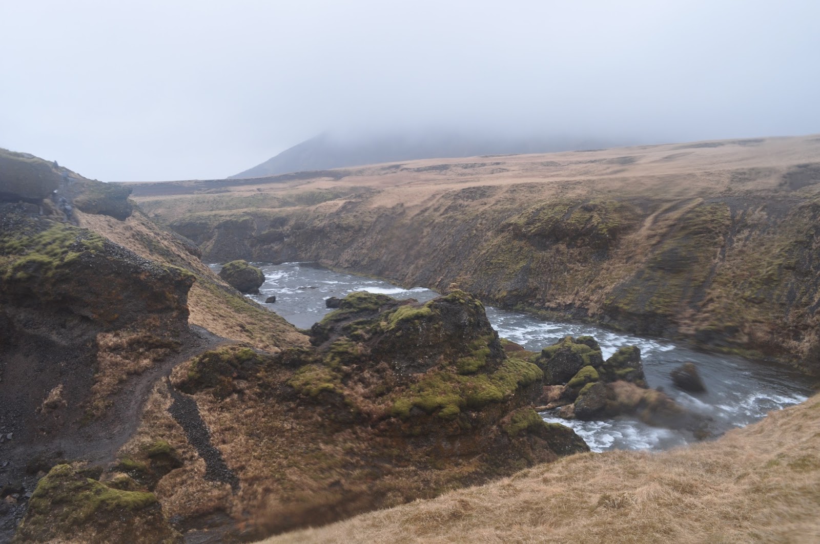


The camera got pretty unhappy in the misty rain, though.


The hike starts/ends at Skógafoss, which was impressive, but I was too cold to really enjoy it!

After our hike, we stopped in the restaurant at Hotel Skógafoss for a warm up. L had a curried chicken soup and I had a lamb soup. Both were delicious! Since our hike was shorter than expected, we headed towards the natural attractions near Vík, the southern-most and rainiest point in Iceland.
Unfortuantely, I can't find the names of some of these places because the library book we used on the trip is no longer available through the Wake County Library. I'm sure glad they kept it until we got back!


Reynishverfi is a black sand beach near Vík with incredible basalt formation. When lava cools, it sometimes hardens into columns perpendicular to the flow. The angle of the columns tells you how much the lava was still moving as it cooled. They generally form as hexagons but can have any number of sides. They aren't small either!


The waves have pounded out a cave, over time.


After exploring the coast, we checked into Vellir guesthouse then went into Vík for dinner. We ate at Sudur Vík. L had a really good pizza and I had a steak sandwich with veggies and Bearnaise sauce, which is a popular combo in Iceland. It was delicious.
No comments:
Post a Comment